Introduction to data type
Radar data represent a specific data that are acquired in the microwave part of electromagnetic spectrum. Owing to that the radar images can be acquired in any weather, in a day or night. Presently, the radar data with spatial resolution tens of meters are available. In the very near future, a 1m resolution will be a reality. Radar data conveniently complement conventional optical data, especially when climatic and meteorological conditions don’t enable getting the optical ones.
(Link: http://www.gisat.cz/content/en/satellite-data/supplied-data/radar-data?senzor=708#sat_detail )
Potential application
-
Floods and floods zones mapping
-
Geomorphologic mapping
-
Monitoring of seismological movements and landslides
-
Ship monitoring, detection of sea and ocean pollution
-
Glaciers mapping and monitoring
-
Tropical forests mapping and monitoring
-
DEM generation
Availability (including suppliers details)
Collection considerations (time of day, FOV, etc.)
- consider the time of day you wish to collect your data and also consider the weather on that day you wish to collect your data, you want a clear and cloudless day, this will give you clear and cloudless images.
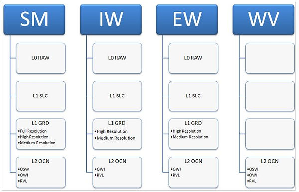
Processing levels
Cost
- Free through USGS
File format
-
a 'manifest.safe' file which holds the general product information in XML
-
subfolders for measurement datasets containing image data in various binary formats
-
a preview folder containing 'quicklooks' in PNG format, Google Earth overlays in KML format and HTML preview files
-
an annotation folder containing the product metadata in XML as well as calibration data
-
a support folder containing the XML schemes describing the product XML
(Link to information: https://sentinel.esa.int/web/sentinel/user-guides/sentinel-1-sar/data-formats/safe-specification )
Coverage
Swath width = 400km
Spatial, spectral, radiometric and temporal resolution
- Spatial resolution: 5.0m, 20.0m, 40.0m
- Radiometric resolution: https://sentinel.esa.int/web/sentinel/user-guides/sentinel-1-sar/resolutions
- Temporal Resolution: Each SENTINEL-1 satellite will be in a near-polar, sun-synchronous orbit, with a 12-day repeat cycle and 175 orbits per cycle. Both SENTINEL-1A and SENTINEL-1B share the same orbit plane with a 180° orbital phasing difference. (Link: https://sentinel.esa.int/web/sentinel/user-guides/sentinel-1-sar/revisit-and-coverage
Spectral range/bands
Software requirements
- PCI
- SNAP
- Geomatica
Processing requirements
- Low
Degree of difficulty
- Low