


Introduction to data type
Satellite data with high resolution are defined by spatial resolution of about tens of meters. These data are often obtained simultaneously in panchromatic and multispectral mode with significant share of spectral bands covering infrared optical spectrum. Some satellites acquire the data solely in a regular, usually a few week period. Other more modern satellites are able to take a data according to the customer’s request. In both cases, extensive data archives are available containing all the images acquired since the launch of the satellite.
The data are suitable for mapping or updating of maps in the scale range 1:100,000 – 1:25,000.
This information can be found following this link: http://www.gisat.cz/content/en/satellite-data/supplied-data/high-resolution
Potential application
The typical applications include:
-
Regional mapping
-
Regional planning
-
Urban development monitoring
-
Land cover/land use mapping and change assessment
-
Vegetation monitoring
-
Mapping of agricultural areas and classification of agricultural crops
-
Mapping of forest areas and classification of forest ecosystem
-
Logging monitoring
-
Geological mapping
-
Geomorphologic mapping
-
Disasters impact(s) mapping
-
DEM generation
Processing levels
Collection considerations (time of day, FOV, etc.)
- Consider the time of day you want to collect your data and also the weather of that day, you want a nice clear day so you have images that are clear of clouds.
Availability (including suppliers details)
(*Note*: The following information is based on Sentinel-2A Satellite and the sensor MSI)
File format
Cost
- Free through USGS
Spatial, spectral, radiometric and temporal resolution
- Spatial Resolution in Meters: 10.0m, 20.0m, 60.0m
- Radiometric resolution is a measure of the ability of an imaging system to record different levels of brightness or tone. The radiometric resolution of SENTINEL-2 is 12-bit. This gives a potential range of brightness levels from
0 - 4 095.
- Temporal resolution is the amount of time, expressed in days, that elapses before a satellite revisits a particular point on the Earth's surface. The satellites in the SENTINEL-2 constellation will provide a revisit time of 5 days at the equator in cloud-free conditions.
Swath width = 290km
Coverage
Spectral range/bands
Software requirements
- PCI
- SNAP
-Geomatica
Processing requirements
- Low
Degree of difficulty
- Low
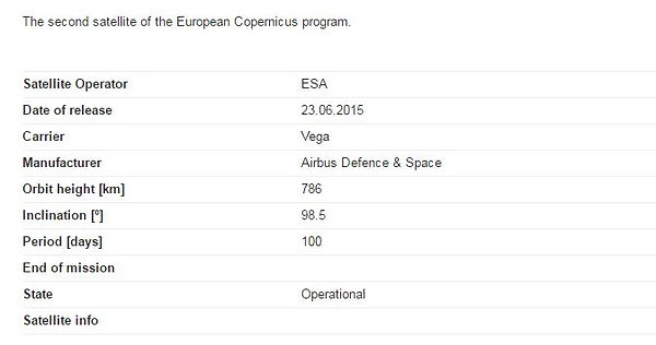
The above screenshot above can be found at this link:
http://www.satimagingcorp.com/satellite-sensors/other-satellite-sensors/sentinel-2a/


